Learning about Worcestershire’s flowers

Learning about Worcestershire’s flowers

Conservation trainees

Patrick is on a mission to become a botanical expert...

I am nearly five months into my training now and that time has flown by! We trainees spend most of our time out on the Trust’s reserves, improving and maintaining the infrastructure and helping to run some of the more complex volunteer tasks, which is all fantastic experience for understanding how a Wildlife Trust functions on a day-to-day basis. We all have additional training goals and one of my personal objectives is to improve my knowledge of Worcestershire’s flora. To achieve this, I have taken advantage of numerous opportunities offered to me.

Back in June, I completed an online course with the Field Studies Council called “Botanical Anatomy”. The aim of the course was to examine the parts of a plant in order to better understand the descriptions in the field guides. It was a deep dive into plant identification and covered features such as the types of leaves, parts of flowers and fruits and seeds. There was also an exercise to dissect and label the parts of a flower of our choice. I thought a creeping buttercup would be very straightforward but, as you see below, it proved to be quite a fiddly task!

A dissection of a creeping buttercup

A dissection of a creeping buttercup by Patrick Taylor

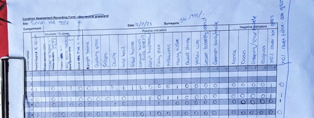
A month later, the trainees spent time with Jasmine, from the Trust's wildlife and farming team, helping to pilot a survey method for monitoring the condition of grassland. This requires some ability to identify flowers and, you guessed it, grasses - the latter being something everyone finds difficult. We spent the first session with some of the volunteers studying one of the flower-rich meadows at Lower Smite Farm. Laying down a 1m by 1m square (known as a quadrat) in the meadow, we looked closely at the species present. Criteria including sward height, presence of “thatch” (decaying vegetation from previous years) and the percentage of bare ground were also recorded. We then looked for the presence of positive indicator species (e.g. black knapweed) and negative indicator species (e.g. docks).  A score was calculated for each square and averaged over all the squares in the meadow to give a measure of its condition. This survey will be repeated every two or three years to determine whether the management of the site is maintaining or improving the quality of the grassland or whether changes need to be made.

A score sheet from the survey of a meadow

A score sheet from the survey of a meadow by Patrick Taylor

In August, my training took me further afield- I spent a weekend with the Field Studies Council at Slapton Ley in south Devon on a course about using the vegetative key to British flora. Previously I have relied on flowers to identify species but problems soon arise when plants don't flower! The vegetative key (by John Poland) enables a botanist to identify plants using only the vegetative parts, such as the stems and the leaves. I was under no illusions as to how difficult this would be! To describe vegetative features requires a very comprehensive set of terminology and as a beginner to this method, I found the course quite tough. 

On the first day, we concentrated on the flowering plants and I could see that, with practice, I could make some headway. On the second day, we moved on to grasses, rushes and conifers and this takes things to a whole new level. I'll need to do a lot of work to become proficient with these groups but this is hardly surprising as I find them quite difficult using a normal field guide!


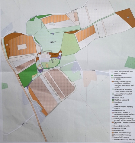
A habitat map of Lower Smite Farm

Habitat map of Lower Smite Farm by Patrick Taylor

More recently, we spent time with Jasmine at Lower Smite Farm to learn about the new UK habitat classification system known as UKHAB. This is intended to replace the old Phase One habitat survey and the National Vegetation Classification (NVC) systems, which were designed in the days of coloured pencils rather than field-based mapping systems on phones and tablets. Jasmine explained the background to the system and showed us some of the documentation. There wasn’t time to demonstrate the mapping systems, other than to show us the current habitat map for Lower Smite Farm.

Our exercise was to look at specific areas of the farm and to classify an example of a meadow, a woodland and a wetland area. The system has multiple levels and if you classify to the lowest level, the manual runs to 565 pages! However, we agreed to use levels one, two and three only and although we had some debate, we all agreed on the classifications quite quickly. This required some of the botanical knowledge gained on our previous surveys and training.

So where next? I am hoping to complete further online courses over the winter so I can start next year’s botany season from a much stronger starting point. Hopefully, I will be out in February with my new vegetative key long before anything is in flower!


A long-standing naturalist, Patrick Taylor has taken the plunge and is loving the change of career from engineering to nature conservation.