Heathland heritage

Heathland heritage

Heathland management through the ages at The Devil's Spittleful

Volunteer and guest blogger Sue Duffield takes a look at how Dropping Well Farm and the surrounding heathland became what they are today...

When recently tasked with the role of providing historical information to a group visiting Dropping Well Farm and its surroundings, the first question I asked myself was "where do I begin?" Having realised that the present character of the area has been shaped by so many different influences, both natural and human, I decided to look at lots of different sources of reference, ranging from books to reports to individual stories. All highlighted the importance of this area of increasingly rare heathland habitat and the many uses of this land over time.

Over the last 200 years it is said that 85% - 90%  of these unique heathland habitats in the UK have disappeared due to agriculture, development or lack of management. Fortunately, in the area around Dropping Well Farm much of the land is being restored to previous periods in its history, when the landscape of Worcestershire was very different from that of today.

Through extensive research, archaeologists have concluded that Worcestershire’s landscape was generally very open for long stretches of time, even during periods considered to be an ‘ice age’. It was characterised by grassland, marshland and sandy heathland grazed by large herbivores, such as bison, woolly mammoths and even giant elephants! On heathland these animals, together with the inevitable occurrence of wild fires, would have provided the clear, well-drained ground required for the establishment of iconic plant species such as heather, gorse and broom. These thrived, especially on the relatively poor sandy soils and open sunlit environment.  Any pioneering tree species such as oak and silver birch, which would  inevitably have ‘taken over’, were controlled by the large grazing animals.

From grazers to people

As human activity began to grow and dominate, many of the large herbivores disappeared, perhaps through cooling of temperatures whilst others were virtually hunted to extinction. In Worcestershire, it is thought that even as early as 6000 years ago, much of the land was used for some form of agriculture, either growing crops or grazing animals. Similar to other parts of the country, Worcestershire’s heathland proved  a useful resource for millennia. It was used for grazing and feeding livestock, providing bedding for animals and people and its vegetation could be burnt as fuel.  Also, as in the case of Dropping Well Farm, large areas were used for growing crops – often on a rotational basis. However, from records it is clear that this was not always a great success due to the poor quality of soil and even with the addition of fertilisers, yields were below expectations even as farming intensified and industrialisation occurred.

Records from the mid 19th century show sheep and/or cows were kept at Dropping Well Farm and much of the land was given over to rough, temporary and permanent pasture. Crop growing was limited due to poor soils, a fact that was particularly highlighted during the national farm surveys conducted in the midst of World War Two when every inch of valuable land was required for growing crops to feed the nation. Until fairly recently, most of the residents of the farm were tenant farmers or agricultural labourers, a variety of farm workers and families. All seem to have struggled to make a good living from the land.

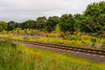
A railway line running through two nature reserves, lined with wildflowers on either side by Paul Lane

The Severn Valley Railway line through The Devil's Spittleful and Dropping Well Farm by Paul Lane

Railways and rifles

The heathland areas surrounding Dropping Well Farm may have periodically been used for agriculture on a shifting cultivation basis and for other purposes mentioned previously. However,  records from the last 150 years have highlighted a chequered history, probably repeated in many other parts of the country. Firstly, visitors cannot fail to notice the prominent presence of what is now called the Severn Valley Railway line. The original main line, which opened in 1862,  ran from Hartlebury to Shrewsbury but in 1878 a loop line was added by Great Western Railways (GWR). This extension, joining Bewdley to Kidderminster, cuts through the middle of the heathland and separates the existing Devil’s Spittleful/Rifle Range reserves from what is now Dropping Well Farm. Although the line closed to passengers in 1963, only two years later a group of enthusiastic volunteers persuaded British Railways to sell the section of line.  After a long period of restoration and reopening, the rest - as the saying goes - is history. Ironically, in hot dry summers, the sparks from passing steam trains could have been a source of wild fires, formerly a way in which the heathland vegetation would have been maintained naturally.

The mound of earth and stone known as The Devil's Spittleful or Spadeful by Wendy Carter

The Devil's Spittleful rock by Wendy Carter

The Devil’s Spittleful nature reserve is now owned and managed by Worcestershire Wildlife Trust. Its name centres around the prominent rocky sandstone knoll crowned with Scots pine trees, known as The Devil’s Spittleful or Spadefull.  A ‘spit’ was a spade’s depth and the area is thought to have got its name from the digging ‘Devil’. There are many versions of this story but one goes like this: the Devil was very angry with the good and righteous people of Bewdley because of their disloyalty. So in revenge, he decided to set out with a huge spadeful of rock with which to dam the mighty River Severn and drown the local settlements. However, on the way he met a very cunning cobbler who realised the Devil’s awful intentions. The cobbler showed a big bag of worn-out shoes to the Devil, pretending that he himself had worn them out whilst trying to find this dreadful place. Discouraged, the Devil dropped his huge spadeful of rock and went back the way he had come. Bewdley was saved!

The area now known as the Rifle Range nature reserve is owned and managed by Wyre Forest District Council and it designated as a Site of Special Scientific Interest (SSSI) due to its heathland flora and fauna. It is now a peaceful, beautiful place but it wasn’t always like that. Between 1882 and 1885, it featured a horse racing track, presumably the flat, open, sandy land was perfect for such events. Several meets took place there with up to 4000 people in attendance.

An advertisement in the Kidderminster Shuttle dated May 1882 invited people to: ‘Kidderminster Races, for Horses, Galloways and Ponies’ with ‘A Splendid Brass Band Engaged for Dancing’ and  ‘a Public Dinner at the Lion Hotel’ -  this must have been a very jovial and noisy occasion. 

The name of ‘The Rifle Range’ first appeared on an Ordnance Survey map of 1902. Before and during World War One, the range was used by local Volunteers, the men who were predecessors to the Territorial Army. They used the area as an artillery range; concrete tracks, firing butts and the remnants of an ammunition store are amongst the few remaining pieces of evidence. As the nearby railway provided a perfect means of transportation for troops, a request stop known as ‘The Rifle Range Halt’ was built by GWR in 1905 at a cost of £145. The Halt, consisting of a timber platform with a shelter over, was about 100 yards long and it was situated near to the bridge over the cart track near to The Devil’s Spittleful. The Halt was officially closed in 1920 but was occasionally used by military personnel on exercises. Once again, the heathland was useful due its flat, dry, open nature – perfect for troops, jeeps and even tanks.

Restoration

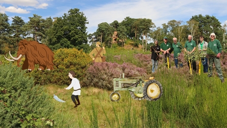
Visitors to The Devil’s Spittleful and Rifle Range reserves are now able to walk through a mosaic of habitat, with open areas dominated by heather and other specialities, such as wavy hair grass, in the grassland areas. This open nature, formerly created by grazing animals and humans with scythes, tractors, military vehicles and tanks, has to be purposefully maintained by rangers and volunteers. Gorse and broom make some areas of the reserves more scrubby whilst silver birch, oak and other pioneering species have created small pockets of woodland. Without management and control, the whole heathland site would become overwhelmed by these species in time. The current combination and balance of heathland, grassland, scrub and woodland provides a habitat for a wide range of plants, butterflies and moths, insects, fungi and birds. Hopefully, as the land immediately around Dropping Well Farm returns to its former heathland condition, there will be even more space and opportunities for these species to colonise.

Illustration of heathland management through time - background of heathland habitat with mammoth illustration, farmer with scythe illustration, soldier with rifle illustration, tractor illustration and photo of a group of modern volunteers

Heathland management through the ages at The Devil's Spittleful

National Lottery Heritage Fund and Severn Waste Services logos